Search Questions
Search
Q: Vishal is standing in a park facing the south direction. He then turns 90º clockwise on the same point. After that, he turns 45º clockwise. In which direction is he facing now?
- A. North-west
- B. South-west
- C. North-east
- D. South-east
Correct Answer:
Option A -
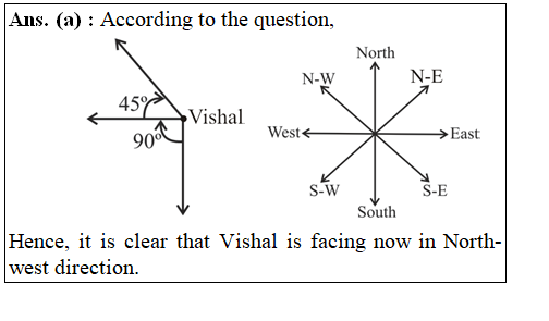
Explanations:
Address
12, Church Ln, The Adelphi, Allen Ganj, Prayagraj, Uttar Pradesh 211002
+91 9554973128
info.yctbooks@gmail.com
Download Our App

