Search Questions
Search
Q: Identify whether the following statements (S1 and S2), pertaining to contour map preparation as a part of topographic survey, are true or false. पहचानें कि स्थलाकृतिक सर्वेक्षण के एक भाग के रूप में समोच्च मानचित्र तैयार करने से संबंधित निम्नलिखित कथन (S1 और S2) सही है या गलत S1: The contour interval should be directly proportional to the scale to which it is proposed to draw the map./ S1:समोच्च रेखान्तर उस पैमाने के सीधे समानुपातिक होना चाहिए जिस पर मानचित्र बनाना प्रस्तावित है। S2: On a very flat terrain, smaller interval and on a hilly terrain, larger interval is adopted as the contour interval./ S2:एक बड़ी समतल भू भाग पर, छोटे अंतराल और पहाड़ी भूभाग पर, बड़े अंतराल को समोच्च रेखान्तर के रूप में अपनाया जाता है।
- A. S1 is true and S2 is false/S1 सही है और S2 गलत है
- B. S1 is false and S2 is true/ S1 गलत है और S2 सही है
- C. Both S1 and S2 are true/ S1 और S2 दोनो सही है।
- D. Both S1 and S2 are false/S1 और S2 दोनों गलत है।
Correct Answer:
Option B -
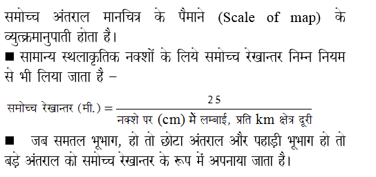
Explanations:
Address
12, Church Ln, The Adelphi, Allen Ganj, Prayagraj, Uttar Pradesh 211002
+91 9554973128
info.yctbooks@gmail.com
Download Our App

