Search Questions
Search
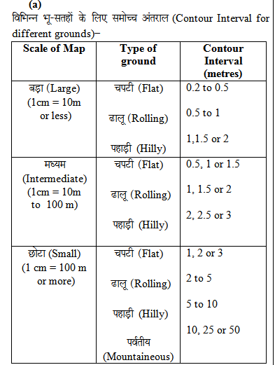
Q: Identify the type of ground and scale of map for 0.5 m to 1 m contour intervals?/0.5 मी. से 1 मी. समोच्च रेखान्तर के लिए जमीन के प्रकार और मानचित्र के पैमाने की पहचान करें?
- A. Rolling ground and large scale ढ़ालू भूमि और बड़ा पैमाना
- B. Hilly ground and intermediate scale पहाड़ी भूमि और माध्यमिक पैमाना
- C. Flat ground and intermediate scale चपटी भूमि और माध्यमिक पैमाना
- D. Flat ground and small scale चपटी भूमि और छोटा पैमाना
Correct Answer:
Option A -
Explanations:
Address
12, Church Ln, The Adelphi, Allen Ganj, Prayagraj, Uttar Pradesh 211002
+91 9554973128
info.yctbooks@gmail.com
Download Our App

